Geolocate

Afton topographic map

Click on the map to display elevation.

About this map

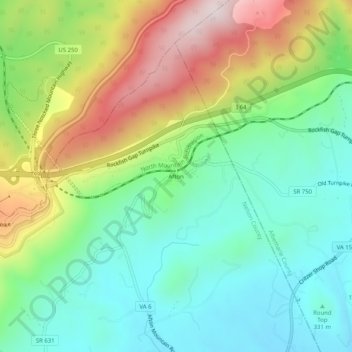
Name: Afton topographic map, elevation, terrain.

Location: Afton, Nelson County, Virginia, 22920, United States (38.01236 -78.85919 38.05236 -78.81919)

Average elevation: 1,440 ft

Minimum elevation: 771 ft

Maximum elevation: 2,674 ft

Nelson County trails, hiking, mountain biking, running and outdoor activities

Other topographic maps

Click on a map to view its topography, its elevation and its terrain.

Tye River

United States > Virginia > Nelson County

Average elevation: 823 ft

Piney River

United States > Virginia > Nelson County

Average elevation: 873 ft

Gear up for your next adventure:

😴Insulated Sleeping Pads - Compact and warm pads for high-elevation camping
📷Action Camera - Capture your outdoor adventures in HD
🛏️Cold Weather Sleeping Bag - Warm sleeping bag for cold conditions
🧴Hand Sanitizer - Keep hands clean while hiking
🔥Fast-Boil Camping Stoves - Efficient cooking systems for quick trail meals

As an Amazon Associate, this site earns from qualifying purchases at no extra cost to you.