
Make a donation
Gear up for your next adventure:
As an Amazon Associate, this site earns from qualifying purchases at no extra cost to you.
Diego Garcia topographic map
Click on the map to display elevation.
Make a donation
Gear up for your next adventure:
As an Amazon Associate, this site earns from qualifying purchases at no extra cost to you.
Diego Garcia
The island consists of the largest continuous dryland rim of all atolls in the world. The dryland rim varies in width from a few hundred metres to 2.4 km. Typical of coral atolls, it has a maximum elevation on some dunes on the ocean side of the rim of 9 m (30 ft) above mean low water. The rim nearly encloses a lagoon about 19 km (12 mi) long and up to 8 km (5.0 mi) wide. The atoll forms a nearly complete rim of land around a lagoon, enclosing 90% of its perimeter, with an opening only in the north. The main island is the largest of about 60 islands which form the Chagos Archipelago. Besides the main island, three small islets are at the mouth of the lagoon: West Island (3.4 ha (8.4 acres)), Middle Island (6 ha (15 acres)) and East Island (11.75 ha (29.0 acres)). A fourth, Anniversary Island, 1 km (1,100 yards) southwest of Middle Island, appears as just a sand bar on satellite images. Both Middle Island and Anniversary Island are part of the Spur Reef complex.
Make a donation
Gear up for your next adventure:
As an Amazon Associate, this site earns from qualifying purchases at no extra cost to you.
About this map
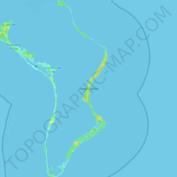
Name: Diego Garcia topographic map, elevation, terrain.
Location: Diego Garcia, Downtown, British Indian Ocean Territory (-7.44390 72.35377 -7.23305 72.49473)
Average elevation: 0 ft
Minimum elevation: -16 ft
Maximum elevation: 66 ft
Make a donation
Gear up for your next adventure:
As an Amazon Associate, this site earns from qualifying purchases at no extra cost to you.