
Senhora da Rocha topographic map
Interactive map
Click on the map to display elevation.
About this map
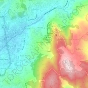
Name: Senhora da Rocha topographic map, elevation, terrain.
Location: Senhora da Rocha, Nogueiró e Tenões, Braga, 4715-110, Portugal (41.53007 -8.40337 41.57007 -8.36337)
Average elevation: 1,050 ft
Minimum elevation: 564 ft
Maximum elevation: 1,870 ft
Other topographic maps
Click on a map to view its topography, its elevation and its terrain.
Braga (São Vicente)
Portugal > Braga > Braga > Dume
Braga (São Vicente), Dume, Braga, Portugal
Average elevation: 528 ft
Nogueiró e Tenões
Nogueiró e Tenões, Braga, Portugal
Average elevation: 1,014 ft