
Make a donation
Gear up for your next adventure:
As an Amazon Associate, this site earns from qualifying purchases at no extra cost to you.
Lamia topographic map
Click on the map to display elevation.
Make a donation
Gear up for your next adventure:
As an Amazon Associate, this site earns from qualifying purchases at no extra cost to you.
About this map
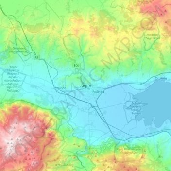
Name: Lamia topographic map, elevation, terrain.
Average elevation: 1,752 ft
Minimum elevation: -13 ft
Maximum elevation: 7,024 ft
Make a donation
Gear up for your next adventure:
As an Amazon Associate, this site earns from qualifying purchases at no extra cost to you.
Other topographic maps
Click on a map to view its topography, its elevation and its terrain.
Δημοτική Ενότητα Γοργοποτάμου
Greece > Thessaly and Central Greece > Phthiotis Regional Unit
Average elevation: 1,867 ft
Municipal Unit of Lamia
Greece > Thessaly and Central Greece > Phthiotis Regional Unit
Average elevation: 1,745 ft
Δημοτική Ενότητα Γοργοποτάμου
Greece > Thessaly and Central Greece > Phthiotis Regional Unit
Average elevation: 1,867 ft
Lamia Municipality
Greece > Thessaly and Central Greece > Phthiotis Regional Unit
Average elevation: 2,005 ft
Make a donation
Gear up for your next adventure:
As an Amazon Associate, this site earns from qualifying purchases at no extra cost to you.