
Make a donation
Gear up for your next adventure:
As an Amazon Associate, this site earns from qualifying purchases at no extra cost to you.
Lamia Municipality topographic map
Click on the map to display elevation.
Make a donation
Gear up for your next adventure:
As an Amazon Associate, this site earns from qualifying purchases at no extra cost to you.
About this map
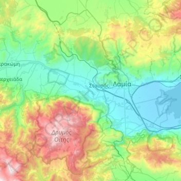
Name: Lamia Municipality topographic map, elevation, terrain.
Average elevation: 2,005 ft
Minimum elevation: -13 ft
Maximum elevation: 7,428 ft
Make a donation
Gear up for your next adventure:
As an Amazon Associate, this site earns from qualifying purchases at no extra cost to you.
Other topographic maps
Click on a map to view its topography, its elevation and its terrain.
Domokos
Greece > Thessaly and Central Greece > Phthiotis Regional Unit > Δημοτική Ενότητα Δομοκού
Average elevation: 1,444 ft
Sarantaina
Greece > Thessaly and Central Greece > Phthiotis Regional Unit > Municipal Unit of Sperchiada
Average elevation: 5,446 ft
Make a donation
Gear up for your next adventure:
As an Amazon Associate, this site earns from qualifying purchases at no extra cost to you.
Kalypso
Greece > Thessaly and Central Greece > Phthiotis Regional Unit > Municipal Unit of Dafnousia
Average elevation: 177 ft
Kallidromo
Greece > Thessaly and Central Greece > Phthiotis Regional Unit > Municipal Unit of Molos
Average elevation: 1,168 ft
Stavros
Greece > Thessaly and Central Greece > Phthiotis Regional Unit > Municipal Unit of Lamia
Average elevation: 276 ft
Make a donation
Gear up for your next adventure:
As an Amazon Associate, this site earns from qualifying purchases at no extra cost to you.
Loutra Thermopilon
Greece > Thessaly and Central Greece > Phthiotis Regional Unit > Municipal Unit of Lamia
Average elevation: 791 ft