
Thank you for supporting this site ❤️
Make a donation
Make a donation
Gear up for your next adventure:
As an Amazon Associate, this site earns from qualifying purchases at no extra cost to you.
Fanhais topographic map
Click on the map to display elevation.
Thank you for supporting this site ❤️
Make a donation
Make a donation
Gear up for your next adventure:
As an Amazon Associate, this site earns from qualifying purchases at no extra cost to you.
About this map
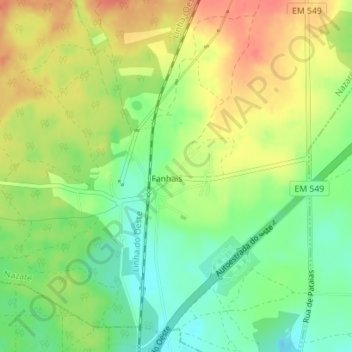
Name: Fanhais topographic map, elevation, terrain.
Location: Fanhais, Nazaré, Leiria, Oeste, Centro, 2460-392, Portugal (39.60707 -9.01644 39.64707 -8.97644)
Average elevation: 203 ft
Minimum elevation: 69 ft
Maximum elevation: 361 ft
Thank you for supporting this site ❤️
Make a donation
Make a donation
Gear up for your next adventure:
As an Amazon Associate, this site earns from qualifying purchases at no extra cost to you.