Geolocate

Lloyd topographic map

Click on the map to display elevation.

About this map

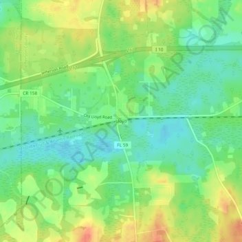
Name: Lloyd topographic map, elevation, terrain.

Location: Lloyd, Jefferson County, Florida, 32337, United States (30.45742 -84.04183 30.49742 -84.00183)

Average elevation: 108 ft

Minimum elevation: 43 ft

Maximum elevation: 197 ft

Jefferson County trails, hiking, mountain biking, running and outdoor activities

Other topographic maps

Click on a map to view its topography, its elevation and its terrain.

Monticello

United States > Florida > Jefferson County

Average elevation: 190 ft

Gear up for your next adventure:

🥇GPS Hiking Watch - Multi‑sport GPS watch with navigation and trail tracking
🗻Climbing Gear Basics - Essential gear for beginner climbers
🧤Hiking Gloves - Protective gloves for rugged trails
🎒Outdoor Daypacks - Lightweight backpacks designed for carrying maps and essential gear
🔥Camping Stove - Portable stove for camping and backcountry cooking

As an Amazon Associate, this site earns from qualifying purchases at no extra cost to you.