Geolocate

Chaperito topographic map

Click on the map to display elevation.

About this map

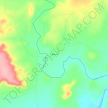
Name: Chaperito topographic map, elevation, terrain.

Location: Chaperito, San Miguel County, New Mexico, United States (35.34588 -104.96527 35.38588 -104.92527)

Average elevation: 5,463 ft

Minimum elevation: 5,289 ft

Maximum elevation: 5,758 ft

Other topographic maps

Click on a map to view its topography, its elevation and its terrain.

Las Vegas

United States > New Mexico > San Miguel County

Average elevation: 6,542 ft

Pecos

United States > New Mexico > San Miguel County

Average elevation: 6,991 ft

Las Vegas

United States > New Mexico > San Miguel County

Average elevation: 6,542 ft

Gear up for your next adventure:

🚑Emergency Bivvies - Heat-reflective sleeping bags for survival situations
🪶Fire Starter Kit - Reliable fire starter for survival and camping
🪶Thermal Camp Blanket - Extra warmth for cold nights
🧭Hiking Compass - Precision compass for reliable navigation in the wilderness
🥤Water Filter Bottle - All‑in‑one filter bottle for safe hydration

As an Amazon Associate, this site earns from qualifying purchases at no extra cost to you.