
Make a donation
Gear up for your next adventure:
As an Amazon Associate, this site earns from qualifying purchases at no extra cost to you.
Auyantepuy topographic map
Click on the map to display elevation.
Make a donation
Gear up for your next adventure:
As an Amazon Associate, this site earns from qualifying purchases at no extra cost to you.
Auyantepuy
El Auyantepuy es un gigante entre las mesetas grandes. Tiene una altitud de 2535 metros y una superficie de unas 70.500 hectáreas o 705 kilómetros cuadrados, lo que quiere decir que tiene una superficie comparable a la de países como Singapur o es mucho más extenso que naciones como Andorra. Desde su cima se precipita la cascada más alta del mundo: el Kerepakupai Vená, más conocido como Salto Ángel.
Make a donation
Gear up for your next adventure:
As an Amazon Associate, this site earns from qualifying purchases at no extra cost to you.
About this map
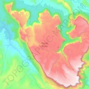
Name: Auyantepuy topographic map, elevation, terrain.
Location: Auyantepuy, Municipio Gran Sabana, Estado Bolívar, Venezuela (5.73365 -62.75998 6.08618 -62.38813)
Average elevation: 3,947 ft
Minimum elevation: 1,243 ft
Maximum elevation: 8,182 ft
Make a donation
Gear up for your next adventure:
As an Amazon Associate, this site earns from qualifying purchases at no extra cost to you.
Other topographic maps
Click on a map to view its topography, its elevation and its terrain.
San Francisco de Yuruaní
Venezuela > Estado Bolívar > Municipio Gran Sabana
Average elevation: 2,904 ft
Make a donation
Gear up for your next adventure:
As an Amazon Associate, this site earns from qualifying purchases at no extra cost to you.
Make a donation
Gear up for your next adventure:
As an Amazon Associate, this site earns from qualifying purchases at no extra cost to you.