
Vanhook topographic map
Click on the map to display elevation.
About this map
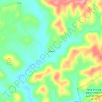
Name: Vanhook topographic map, elevation, terrain.
Location: Vanhook, Pulaski County, Kentucky, United States (37.19397 -84.42216 37.23397 -84.38216)
Average elevation: 1,043 ft
Minimum elevation: 876 ft
Maximum elevation: 1,319 ft
Other topographic maps
Click on a map to view its topography, its elevation and its terrain.
Somerset
United States > Kentucky > Pulaski County
Somerset is located at 37°4′59″N 84°36′34″W / 37.08306°N 84.60944°W / 37.08306; -84.60944 (37.082966, −84.609387), and the downtown (central) part of the city is at an elevation of 974 feet above sea level. The city is located at the eastern end of Kentucky's Mississippian Plateau (or…
Average elevation: 968 ft