
Plainfield topographic map
Click on the map to display elevation.
About this map
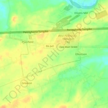
Name: Plainfield topographic map, elevation, terrain.
Average elevation: 495 ft
Minimum elevation: 433 ft
Maximum elevation: 538 ft
Cumberland County trails, hiking, mountain biking, running and outdoor activities
Other topographic maps
Click on a map to view its topography, its elevation and its terrain.
Doubling Gap
United States > Pennsylvania > Cumberland County > Lower Mifflin Township
Average elevation: 1,224 ft
Heron Pond
United States > Pennsylvania > Cumberland County > Penn Township > Huntsdale
Average elevation: 650 ft
Middlesex
United States > Pennsylvania > Cumberland County > Middlesex Township
Average elevation: 449 ft
Walnut Bottom
United States > Pennsylvania > Cumberland County > South Newton Township
Average elevation: 751 ft
Wertzville
United States > Pennsylvania > Cumberland County > Silver Spring Township
Average elevation: 541 ft
West Hill
United States > Pennsylvania > Cumberland County > West Pennsboro Township
Average elevation: 489 ft
Williams Grove
United States > Pennsylvania > Cumberland County > Monroe Township
Average elevation: 486 ft
Summerdale
United States > Pennsylvania > Cumberland County > East Pennsboro Township
Average elevation: 525 ft
Sporting Hill
United States > Pennsylvania > Cumberland County > Hampden Township
Average elevation: 410 ft
Shepherdstown
United States > Pennsylvania > Cumberland County > Upper Allen Township
Average elevation: 502 ft
Hogestown
United States > Pennsylvania > Cumberland County > Silver Spring Township
Average elevation: 413 ft
Grantham
United States > Pennsylvania > Cumberland County > Upper Allen Township
Average elevation: 492 ft
Entlerville
United States > Pennsylvania > Cumberland County > Upper Frankford Township
Average elevation: 843 ft
Caprivi
United States > Pennsylvania > Cumberland County > North Middleton Township
Average elevation: 512 ft
Bowmansdale
United States > Pennsylvania > Cumberland County > Upper Allen Township
Average elevation: 502 ft
Bloserville
United States > Pennsylvania > Cumberland County > Upper Frankford Township
Average elevation: 607 ft
New Kingstown
United States > Pennsylvania > Cumberland County > Silver Spring Township
Average elevation: 449 ft
Boiling Springs
United States > Pennsylvania > Cumberland County > South Middleton Township
Average elevation: 531 ft
Pine Grove Furnace
United States > Pennsylvania > Cumberland County > Cooke Township
Average elevation: 1,089 ft
Greason
United States > Pennsylvania > Cumberland County > West Pennsboro Township
Average elevation: 509 ft
Rosegarden
United States > Pennsylvania > Cumberland County > Upper Allen Township
Average elevation: 469 ft
Sunset Rocks
United States > Pennsylvania > Cumberland County > Cooke Township
Average elevation: 1,171 ft
Lewis Rocks
United States > Pennsylvania > Cumberland County > Southampton Township
Average elevation: 1,516 ft