
Make a donation
Gear up for your next adventure:
As an Amazon Associate, this site earns from qualifying purchases at no extra cost to you.
Le Voide topographic map
Click on the map to display elevation.
Make a donation
Gear up for your next adventure:
As an Amazon Associate, this site earns from qualifying purchases at no extra cost to you.
About this map
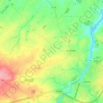
Name: Le Voide topographic map, elevation, terrain.
Average elevation: 348 ft
Minimum elevation: 180 ft
Maximum elevation: 568 ft
Make a donation
Gear up for your next adventure:
As an Amazon Associate, this site earns from qualifying purchases at no extra cost to you.
Other topographic maps
Click on a map to view its topography, its elevation and its terrain.
Champs des Oisillons
France > Pays de la Loire > Maine-et-Loire > Lys-Haut-Layon > Les Oisillons
Average elevation: 302 ft
Forêt de Brignon
France > Pays de la Loire > Maine-et-Loire > Lys-Haut-Layon
Average elevation: 253 ft
Le Crétail
France > Pays de la Loire > Maine-et-Loire > Lys-Haut-Layon > La Roche Coutant
Average elevation: 266 ft
Make a donation
Gear up for your next adventure:
As an Amazon Associate, this site earns from qualifying purchases at no extra cost to you.
Saint-Hilaire-du-Bois
France > Pays de la Loire > Maine-et-Loire > Lys-Haut-Layon
Average elevation: 377 ft
Make a donation
Gear up for your next adventure:
As an Amazon Associate, this site earns from qualifying purchases at no extra cost to you.
Étang du Lys
France > Pays de la Loire > Maine-et-Loire > Lys-Haut-Layon > Le Pont du Lys
Average elevation: 325 ft
Make a donation
Gear up for your next adventure:
As an Amazon Associate, this site earns from qualifying purchases at no extra cost to you.