
Make a donation
Gear up for your next adventure:
As an Amazon Associate, this site earns from qualifying purchases at no extra cost to you.
Agrelo topographic map
Click on the map to display elevation.
Make a donation
Gear up for your next adventure:
As an Amazon Associate, this site earns from qualifying purchases at no extra cost to you.
About this map
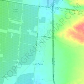
Name: Agrelo topographic map, elevation, terrain.
Average elevation: 3,202 ft
Minimum elevation: 3,130 ft
Maximum elevation: 3,386 ft
Make a donation
Gear up for your next adventure:
As an Amazon Associate, this site earns from qualifying purchases at no extra cost to you.
Other topographic maps
Click on a map to view its topography, its elevation and its terrain.
Dique Potrerillos
Argentina > Mendoza > Departamento Luján de Cuyo > Distrito Cacheuta
Average elevation: 4,980 ft
Make a donation
Gear up for your next adventure:
As an Amazon Associate, this site earns from qualifying purchases at no extra cost to you.
Plaza Bº Villa del Río
Argentina > Mendoza > Departamento Luján de Cuyo > Distrito Ciudad de Luján de Cuyo
Average elevation: 3,143 ft
Puente del Inca
Argentina > Mendoza > Departamento Luján de Cuyo > Puente del Inca
El área natural protegida está localizada en la cordillera de los Andes a una altitud de 2700 msnm, entre los cerros Banderita Norte y Banderita Sur, en el departamento Las Heras, distrito Las Cuevas. Dista 183 km de la ciudad de Mendoza por la ruta nacional 7, cerca del paso a Chile, y de la entrada…
Average elevation: 9,862 ft
Make a donation
Gear up for your next adventure:
As an Amazon Associate, this site earns from qualifying purchases at no extra cost to you.
Distrito Ciudad de Luján de Cuyo
Argentina > Mendoza > Departamento Luján de Cuyo
Average elevation: 3,114 ft
Make a donation
Gear up for your next adventure:
As an Amazon Associate, this site earns from qualifying purchases at no extra cost to you.
Dique Cipolleti
Argentina > Mendoza > Departamento Luján de Cuyo > Distrito Ciudad de Luján de Cuyo
Average elevation: 3,323 ft
Distrito Chacras de Coria
Argentina > Mendoza > Departamento Luján de Cuyo
Average elevation: 3,100 ft
Make a donation
Gear up for your next adventure:
As an Amazon Associate, this site earns from qualifying purchases at no extra cost to you.
Dique Potrerillos
Argentina > Mendoza > Departamento Luján de Cuyo > Distrito Cacheuta
Average elevation: 4,980 ft