
Thank you for supporting this site ❤️
Make a donation
Make a donation
Gear up for your next adventure:
As an Amazon Associate, this site earns from qualifying purchases at no extra cost to you.
独龙江 topographic map
Click on the map to display elevation.
Thank you for supporting this site ❤️
Make a donation
Make a donation
Gear up for your next adventure:
As an Amazon Associate, this site earns from qualifying purchases at no extra cost to you.
About this map
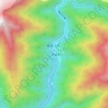
Name: 独龙江 topographic map, elevation, terrain.
Location: 独龙江, 独龙江乡, 贡山独龙族怒族自治县, 怒江傈僳族自治州, 云南省, 中国 (27.84277 98.32783 27.90290 98.34379)
Average elevation: 7,224 ft
Minimum elevation: 4,747 ft
Maximum elevation: 11,224 ft
Thank you for supporting this site ❤️
Make a donation
Make a donation
Gear up for your next adventure:
As an Amazon Associate, this site earns from qualifying purchases at no extra cost to you.
Other topographic maps
Click on a map to view its topography, its elevation and its terrain.