Geolocate

Tracy City topographic map

Click on the map to display elevation.

About this map

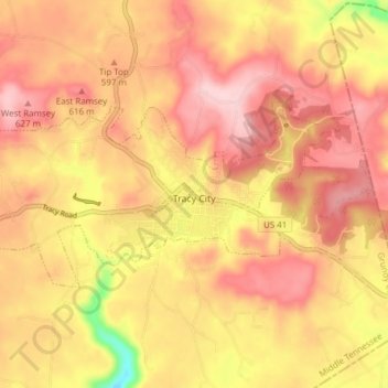
Name: Tracy City topographic map, elevation, terrain.

Location: Tracy City, Grundy County, Middle Tennessee, Tennessee, 37387, United States (35.24602 -85.78372 35.27597 -85.70719)

Average elevation: 1,896 ft

Minimum elevation: 1,460 ft

Maximum elevation: 2,129 ft

Grundy County trails, hiking, mountain biking, running and outdoor activities

Other topographic maps

Click on a map to view its topography, its elevation and its terrain.

Northcutts Cove

United States > Tennessee > Grundy County

Average elevation: 1,490 ft

Pelham

United States > Tennessee > Grundy County

Average elevation: 1,050 ft

Gear up for your next adventure:

❄️Traction Cleats - Prevent slips on icy trails during winter hikes
🏕️Family Camping Gear - Essentials for group camping trips
🧼Biodegradable Camping Soap - Eco‑friendly soap for outdoor hygiene
🌄Hiking Binoculars - Compact binoculars for scenic views and trail spotting
🛌Ultralight Sleeping Bags - Compact down bags for cold nights in the wilderness

As an Amazon Associate, this site earns from qualifying purchases at no extra cost to you.