
Chichester topographic map
Click on the map to display elevation.
About this map
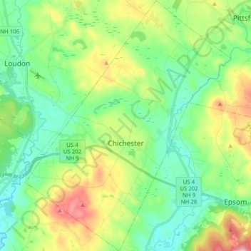
Name: Chichester topographic map, elevation, terrain.
Average elevation: 531 ft
Minimum elevation: 266 ft
Maximum elevation: 1,115 ft
Merrimack County trails, hiking, mountain biking, running and outdoor activities
Other topographic maps
Click on a map to view its topography, its elevation and its terrain.
Ragged Mountain
United States > New Hampshire > Merrimack County > Danbury
Average elevation: 1,627 ft
Kelleys Corner
United States > New Hampshire > Merrimack County > Chichester
Average elevation: 518 ft
Newbury
United States > New Hampshire > Merrimack County > Newbury > Newbury
According to the United States Census Bureau, the town has a total area of 38.1 square miles (98.7 km2), of which 35.8 square miles (92.8 km2) are land and 2.3 square miles (5.9 km2) are water, comprising 5.94% of the town. Mount Sunapee, the highest point in town, has an elevation of 2,726 feet (831 m) above…
Average elevation: 1,496 ft
North Pembroke
United States > New Hampshire > Merrimack County > Pembroke > North Pembroke
Average elevation: 650 ft
Salisbury Heights
United States > New Hampshire > Merrimack County > Salisbury > Salisbury Heights
Average elevation: 804 ft