
Make a donation
Gear up for your next adventure:
As an Amazon Associate, this site earns from qualifying purchases at no extra cost to you.
Lüttringhausen topographic map
Click on the map to display elevation.
Make a donation
Gear up for your next adventure:
As an Amazon Associate, this site earns from qualifying purchases at no extra cost to you.
About this map
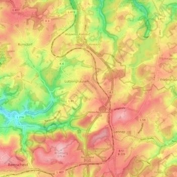
Name: Lüttringhausen topographic map, elevation, terrain.
Average elevation: 961 ft
Minimum elevation: 528 ft
Maximum elevation: 1,250 ft
Make a donation
Gear up for your next adventure:
As an Amazon Associate, this site earns from qualifying purchases at no extra cost to you.
Other topographic maps
Click on a map to view its topography, its elevation and its terrain.
Remscheid
Deutschland > Nordrhein-Westfalen > Remscheid
Remscheid liegt auf den Höhen des Bergischen Landes im Innern des großen Wupperbogens, über den tief eingeschnittenen Tälern des Eschbachs, des Morsbaches und der Wupper und ihrer Seitentäler östlich von Solingen und südlich von Wuppertal, welche zugleich die beiden nächsten größeren Städte sind.
Average elevation: 735 ft
Make a donation
Gear up for your next adventure:
As an Amazon Associate, this site earns from qualifying purchases at no extra cost to you.
Make a donation
Gear up for your next adventure:
As an Amazon Associate, this site earns from qualifying purchases at no extra cost to you.