
Make a donation
Gear up for your next adventure:
As an Amazon Associate, this site earns from qualifying purchases at no extra cost to you.
La Plante topographic map
Click on the map to display elevation.
Make a donation
Gear up for your next adventure:
As an Amazon Associate, this site earns from qualifying purchases at no extra cost to you.
About this map
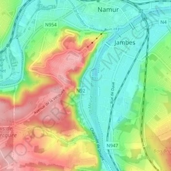
Name: La Plante topographic map, elevation, terrain.
Location: La Plante, Namur, Wallonie, 5000, Belgique (50.42873 4.83791 50.46873 4.87791)
Average elevation: 423 ft
Minimum elevation: 233 ft
Maximum elevation: 722 ft
Make a donation
Gear up for your next adventure:
As an Amazon Associate, this site earns from qualifying purchases at no extra cost to you.
Other topographic maps
Click on a map to view its topography, its elevation and its terrain.
Citadelle de Namur
Belgique > Namur > Namur > Namur
Le site est divisé en trois parties (strates) : Donjon, représentant la partie inférieure, Médiane pour la partie intermédiaire et Terra Nova pour la partie supérieure. Son sommet culmine à 190 m d'altitude.
Average elevation: 367 ft
Make a donation
Gear up for your next adventure:
As an Amazon Associate, this site earns from qualifying purchases at no extra cost to you.
Make a donation
Gear up for your next adventure:
As an Amazon Associate, this site earns from qualifying purchases at no extra cost to you.
Make a donation
Gear up for your next adventure:
As an Amazon Associate, this site earns from qualifying purchases at no extra cost to you.
Namur
Belgique > Namur > Namur > Namur
Le cours de la Meuse moyenne s'est développé dans une vallée en auge, bordée par de hautes falaises calcaires, nettement visibles en amont (Dave) et en aval (Marche-les-Dames) de Namur. La Sambre paresse quant à elle dans des plaines au relief plus faiblement marqué, y décrivant de larges boucles. Au…
Average elevation: 410 ft
Make a donation
Gear up for your next adventure:
As an Amazon Associate, this site earns from qualifying purchases at no extra cost to you.
Make a donation
Gear up for your next adventure:
As an Amazon Associate, this site earns from qualifying purchases at no extra cost to you.
Make a donation
Gear up for your next adventure:
As an Amazon Associate, this site earns from qualifying purchases at no extra cost to you.
Malonne
Belgique > Namur > Namur > Namur
Malonne est un village aux habitations disséminées en de nombreux quartiers et lieux-dits plus ou moins distants les uns des autres, parfois séparés par des bois (ceux-ci représentent d'ailleurs 27 % de la superficie de la section) qui faisaient partie de la grande forêt de Marlagne. L'ancien cœur du…
Average elevation: 509 ft
Make a donation
Gear up for your next adventure:
As an Amazon Associate, this site earns from qualifying purchases at no extra cost to you.
Make a donation
Gear up for your next adventure:
As an Amazon Associate, this site earns from qualifying purchases at no extra cost to you.
Make a donation
Gear up for your next adventure:
As an Amazon Associate, this site earns from qualifying purchases at no extra cost to you.
Make a donation
Gear up for your next adventure:
As an Amazon Associate, this site earns from qualifying purchases at no extra cost to you.
Make a donation
Gear up for your next adventure:
As an Amazon Associate, this site earns from qualifying purchases at no extra cost to you.
Make a donation
Gear up for your next adventure:
As an Amazon Associate, this site earns from qualifying purchases at no extra cost to you.
Malonne
Belgique > Namur > Namur > Namur
Malonne est un village aux habitations disséminées en de nombreux quartiers et lieux-dits plus ou moins distants les uns des autres, parfois séparés par des bois (ceux-ci représentent d'ailleurs 27 % de la superficie de la section) qui faisaient partie de la grande forêt de Marlagne. L'ancien cœur du…
Average elevation: 509 ft