Geolocate

Currie topographic map

Click on the map to display elevation.

Currie

The period 1921-1951 brought great changes with the building of more council houses in Currie and private building along Lanark Road. Wider scale development began in the late 1950s and early 1960s with the construction of a private housing estate to the east of Curriehill Road. House builders began to promote Currie as a pleasant commuting suburb of Edinburgh and much house building took place to the north of Lanark Road West. Currie High School was constructed on its present site in 1966 and extensively refurbished and renewed in 1997. There was a Currie station on a short loop railway running over what is now the Water of Leith Walkway. The physical topography has ensured that the original historic core to the south of Lanark Road West including the Water of Leith has remained undeveloped. In March 1972 the historic centre of Currie was declared a Conservation Area.

Wikipedia (CC-BY-SA 3.0)

About this map

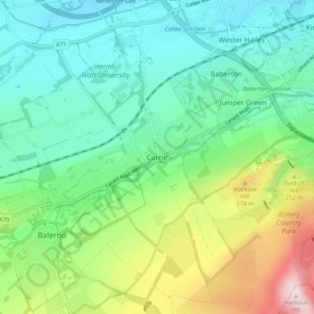
Name: Currie topographic map, elevation, terrain.

Location: Currie, City of Edinburgh, Scotland, United Kingdom (55.87122 -3.34942 55.92152 -3.26916)

Average elevation: 535 ft

Minimum elevation: 197 ft

Maximum elevation: 1,375 ft

Other topographic maps

Click on a map to view its topography, its elevation and its terrain.

Ratho

United Kingdom > Scotland > City of Edinburgh

Average elevation: 262 ft

Hillend

United Kingdom > Scotland > City of Edinburgh > Ratho

Average elevation: 220 ft

Gogar

United Kingdom > Scotland > City of Edinburgh

Average elevation: 167 ft

Newbridge

United Kingdom > Scotland > City of Edinburgh

Average elevation: 177 ft

Calton Hill

United Kingdom > Scotland > City of Edinburgh

Average elevation: 177 ft

Crow Hill

United Kingdom > Scotland > City of Edinburgh

Average elevation: 223 ft

Calton Hill

United Kingdom > Scotland > City of Edinburgh

Average elevation: 177 ft

Castle Rock

United Kingdom > Scotland > City of Edinburgh

Average elevation: 217 ft

The Meadows

United Kingdom > Scotland > City of Edinburgh

Average elevation: 256 ft

Gogarbank

United Kingdom > Scotland > City of Edinburgh

Average elevation: 226 ft

Calton Hill

United Kingdom > Scotland > City of Edinburgh

Average elevation: 177 ft

Hillend

United Kingdom > Scotland > City of Edinburgh > Ratho

Average elevation: 220 ft

Gear up for your next adventure:

🥾Hiking Shoes - Durable and comfortable shoes for trail hiking
🎒Gear Packing Cubes - Organize your backpack efficiently
🛌Ultralight Sleeping Bags - Compact down bags for cold nights in the wilderness
📡Handheld GPS Device - Reliable handheld GPS for outdoor navigation
🌲Outdoor Survival Books - Best books on survival skills

As an Amazon Associate, this site earns from qualifying purchases at no extra cost to you.