Geolocate
👉 Easily get elevation data in JSON, GeoTIFF and KML formats using Elevation API
Thank you for supporting this site ❤️
Make a donation

Greeley topographic map

Click on the map to display elevation.

About this map

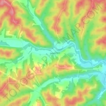
Name: Greeley topographic map, elevation, terrain.

Location: Greeley, Reynolds County, Missouri, United States (37.49505 -91.20708 37.53505 -91.16708)

Average elevation: 1,115 ft

Minimum elevation: 951 ft

Maximum elevation: 1,293 ft

Reynolds County trails, hiking, mountain biking, running and outdoor activities

Gear up for your next adventure:

🥾Women's Hiking Boots - Top-rated trail boots with ankle support and superior grip
🥄Camping Utensil Set - Lightweight utensils for outdoor meals
🧦Merino Wool Socks - Moisture-wicking, blister-preventing socks for long treks
🪶Fire Starter Kit - Reliable fire starter for survival and camping
🧭Pro Hiking Compasses - High-accuracy liquid-filled compasses for topographic orientation

As an Amazon Associate, this site earns from qualifying purchases at no extra cost to you.