
Make a donation
Gear up for your next adventure:
As an Amazon Associate, this site earns from qualifying purchases at no extra cost to you.
Marminhac topographic map
Click on the map to display elevation.
Make a donation
Gear up for your next adventure:
As an Amazon Associate, this site earns from qualifying purchases at no extra cost to you.
About this map
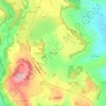
Name: Marminhac topographic map, elevation, terrain.
Average elevation: 2,562 ft
Minimum elevation: 2,169 ft
Maximum elevation: 3,015 ft
Make a donation
Gear up for your next adventure:
As an Amazon Associate, this site earns from qualifying purchases at no extra cost to you.
Other topographic maps
Click on a map to view its topography, its elevation and its terrain.
Forteresse de Polignac
France > Auvergne-Rhône-Alpes > Haute-Loire > Polignac
Situé à 5 km au nord-ouest du Puy, le château fort de Polignac (on dit aussi la forteresse de Polignac) occupe une butte ou plate-forme basaltique, fragment d'une ancienne coulée volcanique. Le sommet de la butte, à peu près plat, mesure environ 120 m sur 90 m et sa grande longueur est orientée plus ou…
Average elevation: 2,418 ft