
Thank you for supporting this site ❤️
Make a donation
Make a donation
Gear up for your next adventure:
As an Amazon Associate, this site earns from qualifying purchases at no extra cost to you.
Los Navalucillos topographic map
Click on the map to display elevation.
Thank you for supporting this site ❤️
Make a donation
Make a donation
Gear up for your next adventure:
As an Amazon Associate, this site earns from qualifying purchases at no extra cost to you.
Los Navalucillos
El clima es mediterráneo continental, por su altitud y su lejanía respecto al mar. Los termómetros oscilan entre los 25'3ºC de julio y los 5'7ºC de enero, siendo la temperatura media anual de 14'4ºC.
Thank you for supporting this site ❤️
Make a donation
Make a donation
Gear up for your next adventure:
As an Amazon Associate, this site earns from qualifying purchases at no extra cost to you.
About this map
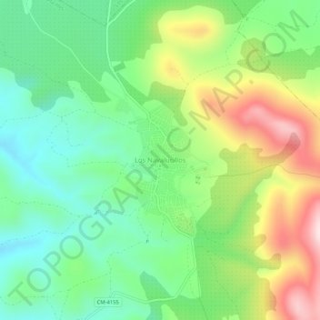
Name: Los Navalucillos topographic map, elevation, terrain.
Average elevation: 2,530 ft
Minimum elevation: 2,054 ft
Maximum elevation: 3,360 ft
Thank you for supporting this site ❤️
Make a donation
Make a donation
Gear up for your next adventure:
As an Amazon Associate, this site earns from qualifying purchases at no extra cost to you.