
Make a donation
Gear up for your next adventure:
As an Amazon Associate, this site earns from qualifying purchases at no extra cost to you.
Fériana topographic map
Click on the map to display elevation.
Make a donation
Gear up for your next adventure:
As an Amazon Associate, this site earns from qualifying purchases at no extra cost to you.
Fériana
Située dans la partie sud de la dorsale tunisienne, à 745 mètres d'altitude, c'est l'une des villes les plus élevées de Tunisie. Elle possède un climat semi-aride à hiver frais et reçoit environ 350 millimètres de pluie par an. La végétation y est rare sauf quelques steppes d'alfa (spartum lygum) et vestiges d'une forêt de pins d'Alep.
Make a donation
Gear up for your next adventure:
As an Amazon Associate, this site earns from qualifying purchases at no extra cost to you.
About this map
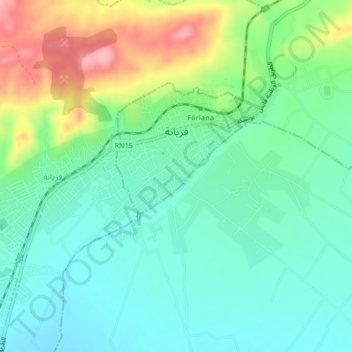
Name: Fériana topographic map, elevation, terrain.
Average elevation: 2,461 ft
Minimum elevation: 2,326 ft
Maximum elevation: 2,766 ft
Make a donation
Gear up for your next adventure:
As an Amazon Associate, this site earns from qualifying purchases at no extra cost to you.