
Potosí topographic map
Interactive map
Click on the map to display elevation.
About this map
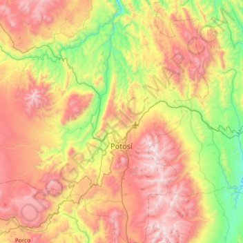
Name: Potosí topographic map, elevation, terrain.
Location: Potosí, Provincia Tomás Frías, Potosí, Bolivia (-19.80525 -65.96351 -19.26264 -65.54740)
Average elevation: 12,995 ft
Minimum elevation: 10,190 ft
Maximum elevation: 16,450 ft
Other topographic maps
Click on a map to view its topography, its elevation and its terrain.
Pucara
Bolivia > Potosí > Provincia Tomás Frías > Potosí
Pucara, Potosí, Provincia Tomás Frías, Potosí, Bolivia
Average elevation: 12,346 ft