
Doren topographic map
Interactive map
Click on the map to display elevation.
Doren
Die Ortsmitte hat eine Höhe von 711 m ü. A., der tiefste Punkt ist die Rotachmündung mit 460 und der höchste Punkt die Haldenhöhe mit 960 m ü. A. Die Gemeinde hat eine Fläche von vierzehn Quadratkilometer. Davon ist fast die Hälfte landwirtschaftliche Nutzfläche, mehr als vierzig Prozent sind bewaldet.
About this map
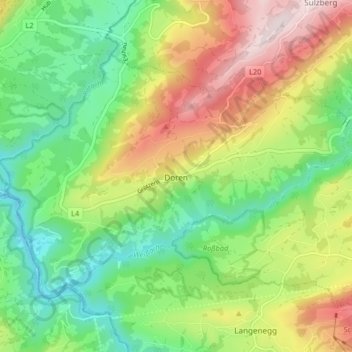
Name: Doren topographic map, elevation, terrain.
Location: Doren, Bezirk Bregenz, Vorarlberg, 6933, Österreich (47.47337 9.83790 47.51178 9.91988)
Average elevation: 2,185 ft
Minimum elevation: 1,467 ft
Maximum elevation: 3,337 ft
Other topographic maps
Click on a map to view its topography, its elevation and its terrain.
Kanisfluh
Österreich > Vorarlberg > Bezirk Bregenz > Mellau
Der Hauptgipfel Holenke befindet sich auf einer Höhe von 2044 m ü. A. und kann über einen bequemen Bergwanderweg (T2) bestiegen werden. Weitere Gipfel sind der Hohe Stoß (1806 m ü. A.), der Runde Kopf (2014 m ü. A.) und die Sonnenspitze (1965 m ü. A.). Diese sind jedoch nur weglos zu erreichen und…
Average elevation: 4,213 ft
Hoher Ifen
Österreich > Vorarlberg > Bezirk Bregenz > Egg
Nordöstlich des Ifenplateaus befindet sich das Gottesackerplateau, eine unter Naturschutz stehende Karstlandschaft mit zahlreichen Höhlen und seltenen Gebirgspflanzen. Die bedeutendsten Höhlen sind das Hölloch im Mahdtal und die Schneckenlochhöhle bei Schönenbach. Am östlichen Abhang des Bergstocks…
Average elevation: 5,991 ft
Winterstaude
Österreich > Vorarlberg > Bezirk Bregenz > Egg
Maximal beträgt die Luftlinien-Entfernung zwischen diesen Gipfeln 5,5 Kilometer. Die Schartenhöhe der Winterstaude beträgt mindestens 837 Meter, ihre Dominanz 6,6 Kilometer, wobei der Diedamskopf jeweils Referenzberg ist.
Average elevation: 4,711 ft
Widderstein
Österreich > Vorarlberg > Bezirk Bregenz > Mittelberg
Der Widderstein (auch Großer Widderstein) ist ein 2533 m ü. A. hoher Berg in Vorarlberg im westlichen Österreich. Topografisch gehört er zu den Südöstlichen Walsertaler Bergen der Allgäuer Alpen. Er ist der höchste Berg dieser Gruppe.
Average elevation: 6,053 ft
Riezlern
Österreich > Vorarlberg > Bezirk Bregenz
Das Dorf liegt etwa 9 Kilometer südwestlich von Oberstdorf am Anfang des Tales 4 Kilometer nach der Grenze. Es befindet sich rechts der Breitach, dem Hauptbach des Tales, auf ca. 1089 m ü. A. Höhe. Es hat ca. 250 Adressen.
Average elevation: 4,167 ft
Bildstein
Österreich > Vorarlberg > Bezirk Bregenz > Gemeinde Bildstein
Bildstein liegt im westlichsten Bundesland Österreichs, Vorarlberg, im Bezirk Bregenz südlich des Bodensees auf 659 Metern Höhe (Ortskern). 45,1 % der Fläche sind bewaldet. Es existieren keine weiteren Katastralgemeinden in Bildstein. Die höchste Erhebung ist der Schneiderkopf mit 971 m ü. A. an der…
Average elevation: 1,919 ft
Körbersee
Österreich > Vorarlberg > Bezirk Bregenz > Gemeinde Schröcken > Schröcken
Der Körbersee befindet sich südwestlich des Hochtannbergpasses im österreichischen Bundesland Vorarlberg im Gemeindegebiet von Schröcken. Er liegt im Lechquellengebirge auf einer Höhe von 1654 m ü. A. und kann nur zu Fuß erreicht werden.
Average elevation: 5,427 ft
Bödele
Österreich > Vorarlberg > Bezirk Bregenz > Gemeinde Schwarzenberg
Der Losenpass verbindet auf einer Meereshöhe von 1.139 Meter die Talschaften Rheintal und Bregenzerwald. Die höchste Erhebung im Bödelegebiet ist der Hochälpelekopf mit einer Höhe von 1464 m.
Average elevation: 3,369 ft
Warth
Österreich > Vorarlberg > Bezirk Bregenz > Gemeinde Warth
Warth liegt im Bezirk Bregenz etwa 42 km südöstlich des Bodensees auf 1495 m Höhe am Tannberg. Dort befindet sich die Ortschaft nur etwas südlich des Haldenwanger Ecks. Mit der offiziellen Seehöhe von 1495 m ü. A. ist Warth die höchstgelegene Vorarlberger Gemeinde. Warth ist die östlichste Gemeinde,…
Average elevation: 5,587 ft
Baad
Österreich > Vorarlberg > Bezirk Bregenz > Gemeinde Mittelberg
Baad liegt am Ende des Kleinwalsertals, noch etwa 4 km hinter Mittelberg, auf etwa 1244 m ü. A. Höhe. Der Ort ist ein Ortschaftsbestandteil der Ortschaft Mittelberg, wird aber ortsüblich als eigenständiger Ortsteil gerechnet. Er umfasst, zusammen mit der kleinen Ortslage Vorderboden, etwa 35 Gebäude mit…
Average elevation: 5,112 ft
Pfänder
Österreich > Vorarlberg > Bezirk Bregenz > Lochau
Der Pfänder ist der zweithöchste Punkt des Höhenrückens, der sich im Osten des Bodensees, oberhalb von Bregenz und Lochau, über eine Strecke von etwa 5 Kilometern hinzieht. Der höchste Gipfel der Kette ist der Hochberg (1069 m).
Average elevation: 2,710 ft
Riezlern
Österreich > Vorarlberg > Bezirk Bregenz > Gemeinde Mittelberg
Das Dorf Riezlern liegt etwa 9 Kilometer südwestlich von Oberstdorf, am Anfang des Tales 4 Kilometer nach der Grenze. Es befindet sich rechts der Breitach, dem Hauptbach des Tales, auf ca. 1089 m ü. A. Höhe. Es hat ca. 250 Adressen.
Average elevation: 4,167 ft
Damüls
Österreich > Vorarlberg > Bezirk Bregenz > Gemeinde Damüls
Damüls ist der höchstgelegene Urlaubsort zwischen dem Bregenzerwald und dem Großen Walsertal und liegt im westlichsten Bundesland Österreichs, Vorarlberg, im Bezirk Bregenz auf 1429 Metern Höhe. Die Gemeinde befindet sich im Tal des Argenbachs, eingebettet zwischen den Damülser Bergen im Norden, und…
Average elevation: 5,226 ft
Kleinwalsertal
Österreich > Vorarlberg > Bezirk Bregenz > Gemeinde Mittelberg
Im Sommer kommen die Gäste meist zum Wandern und Bergwandern. Die Wanderwege erstrecken sich über drei Höhenlagen zwischen 1.086 und 2.536 m. Das Wegenetz besteht aus 185 km naturbelassenen, markierten Wanderwegen. Sie werden von 40 Hütten, Sennalpen und Bergrestaurant flankiert. Das Kleinwalsertal ist…
Average elevation: 4,793 ft
Mohnenfluh
Österreich > Vorarlberg > Bezirk Bregenz > Gemeinde Schröcken
Der Name „Mohn(-en)“ stehe möglicherweise im Zusammenhang mit dem Mond. Da sich in der Nähe auch Bergmähder befinden, kann auch eine Ableitung von Mahd/Mähen gegeben sein. Adelung nennt als Bedeutung für „Fluh“ („Fluhe“) in seinem Grammatisch-kritischen Wörterbuch der Hochdeutschen Mundart,…
Average elevation: 6,608 ft