
Make a donation
Gear up for your next adventure:
As an Amazon Associate, this site earns from qualifying purchases at no extra cost to you.
Mackenzie topographic map
Click on the map to display elevation.
Make a donation
Gear up for your next adventure:
As an Amazon Associate, this site earns from qualifying purchases at no extra cost to you.
About this map
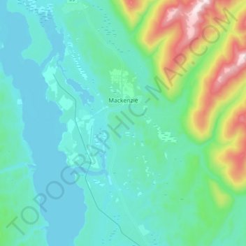
Name: Mackenzie topographic map, elevation, terrain.
Average elevation: 2,713 ft
Minimum elevation: 2,156 ft
Maximum elevation: 5,531 ft
Make a donation
Gear up for your next adventure:
As an Amazon Associate, this site earns from qualifying purchases at no extra cost to you.
Other topographic maps
Click on a map to view its topography, its elevation and its terrain.
Upper Fraser
Canada > British Columbia > Regional District of Fraser-Fort George > Area F (Willow River/Upper Fraser)
Average elevation: 2,123 ft
Hixon
Canada > British Columbia > Regional District of Fraser-Fort George > Area E (Woodpecker/Hixon)
Average elevation: 2,241 ft