Geolocate

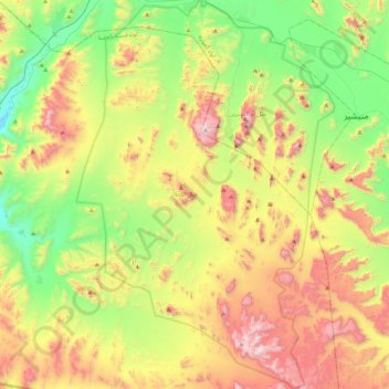
Wadi Rum Protected Area topographic map

Click on the map to display elevation.

Wadi Rum Protected Area

The area is centered on the main valley of Wadi Rum. The highest elevation in Jordan is Jabal Umm ad Dami at 1,840 m (6,040 ft) high (SRTM data states 1854 m), located 30 kilometers south of Wadi Rum village. It was first located by Difallah Ateeg, a Zalabia Bedouin from Rum. On a clear day, it is possible to see the Red Sea and the Saudi border from the top.

Wikipedia (CC-BY-SA 3.0)

About this map

Name: Wadi Rum Protected Area topographic map, elevation, terrain.

Location: Wadi Rum Protected Area, Aqaba Sub-District, Aqaba Qasabah District, Aqaba, Jordan (29.32171 35.25061 29.70063 35.54084)

Average elevation: 3,415 ft

Minimum elevation: 1,932 ft

Maximum elevation: 5,692 ft

Other topographic maps

Click on a map to view its topography, its elevation and its terrain.
Aqaba

Jordan > Aqaba > Aqaba Sub-District

Average elevation: 1,496 ft

Aqaba

Jordan > Aqaba > Aqaba Sub-District

Average elevation: 1,496 ft

Aqaba

Jordan > Aqaba > Aqaba Sub-District

Average elevation: 1,496 ft

Aqaba

Jordan > Aqaba > Aqaba Sub-District

Average elevation: 1,496 ft

Askān al Mīnā’

Jordan > Aqaba > Aqaba Sub-District

Average elevation: 443 ft

Jabal Khazali

Jordan > Aqaba > Aqaba Sub-District

Average elevation: 3,737 ft

Jabal Akhdar

Jordan > Aqaba > Aqaba Sub-District

Average elevation: 2,579 ft

Gear up for your next adventure:

🕶️GPS Smartphone Mount - Secure mount for phone navigation
🥘Titanium Cookware - Durable, featherlight pots and pans for backpacking
🔪Outdoor Multitools - Essential survival tools for gear repair and field use
🪶Camping Sleeping Pad - Comfortable sleeping pad for backpacking
🧢Outdoor Hiking Hat - Sun protection hat for outdoor explorers

As an Amazon Associate, this site earns from qualifying purchases at no extra cost to you.