Geolocate

Chaurangikhal topographic map

Click on the map to display elevation.

About this map

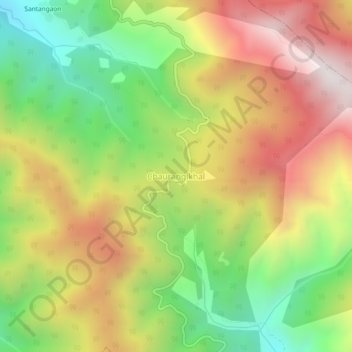
Name: Chaurangikhal topographic map, elevation, terrain.

Location: Chaurangikhal, Dunda, Uttarkashi district, Uttarakhand, India (30.62499 78.46770 30.66499 78.50770)

Average elevation: 7,441 ft

Minimum elevation: 5,600 ft

Maximum elevation: 9,426 ft

Gear up for your next adventure:

📡Handheld GPS Device - Reliable handheld GPS for outdoor navigation
🛏️Cold Weather Sleeping Bag - Warm sleeping bag for cold conditions
🎒Trail Energy Bars - High‑calorie bars for hiking energy
🔌Solar Panel Charger - Charge gear sustainably outdoors
⛑️Personal Locator Beacon - Safety beacon for emergencies

As an Amazon Associate, this site earns from qualifying purchases at no extra cost to you.