Geolocate

Stanton topographic map

Click on the map to display elevation.

About this map

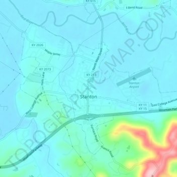
Name: Stanton topographic map, elevation, terrain.

Location: Stanton, Powell County, Kentucky, United States (37.83285 -83.87717 37.86195 -83.82824)

Average elevation: 705 ft

Minimum elevation: 620 ft

Maximum elevation: 1,260 ft

Powell County trails, hiking, mountain biking, running and outdoor activities

Other topographic maps

Click on a map to view its topography, its elevation and its terrain.

Slade

United States > Kentucky > Powell County

Average elevation: 1,020 ft

Vaughns Mill

United States > Kentucky > Powell County

Average elevation: 722 ft

Gray's Arch

United States > Kentucky > Powell County

Average elevation: 1,083 ft

Slade

United States > Kentucky > Powell County

Average elevation: 1,020 ft

Slade

United States > Kentucky > Powell County

Average elevation: 1,020 ft

Gear up for your next adventure:

🔭Compact Binoculars - HD vision for scouting terrain and identifying distant landmarks
🦺Reflective Outdoor Gear - Safety gear for low‑light conditions
🔋Solar Power Banks - Keep your GPS and phone charged in remote wilderness areas
📶Satellite Messenger - Communication device off‑grid
🌧️Backpack Rain Cover - Keep gear dry in wet weather

As an Amazon Associate, this site earns from qualifying purchases at no extra cost to you.