Geolocate

Scappoose topographic map

Click on the map to display elevation.

About this map

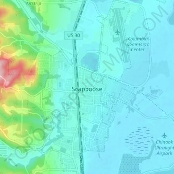
Name: Scappoose topographic map, elevation, terrain.

Location: Scappoose, Columbia County, Oregon, United States (45.73554 -122.90313 45.78002 -122.85650)

Average elevation: 102 ft

Minimum elevation: 0 ft

Maximum elevation: 686 ft

Columbia County trails, hiking, mountain biking, running and outdoor activities

Other topographic maps

Click on a map to view its topography, its elevation and its terrain.

Camp Wilkerson

United States > Oregon > Columbia County

Average elevation: 1,283 ft

Deer Island

United States > Oregon > Columbia County

Average elevation: 151 ft

Inglis

United States > Oregon > Columbia County

Average elevation: 249 ft

Gear up for your next adventure:

🔌Solar Panel Charger - Charge gear sustainably outdoors
🧢Sun Protection Hats - Wide-brimmed and UPF-rated hats for high-altitude sun safety
🪶Compact Camp Shovel - Folding shovel for campsite tasks
🌧️Backpack Rain Cover - Keep gear dry in wet weather
📱Solar Portable Charger - Solar power bank for charging devices off‑grid

As an Amazon Associate, this site earns from qualifying purchases at no extra cost to you.