
Make a donation
Gear up for your next adventure:
As an Amazon Associate, this site earns from qualifying purchases at no extra cost to you.
Jößnitz topographic map
Click on the map to display elevation.
Make a donation
Gear up for your next adventure:
As an Amazon Associate, this site earns from qualifying purchases at no extra cost to you.
Jößnitz
Veranstaltungen finden meist im Gemeindezentrum Hasengrund oder im alten Bahnhofsgebäude, das zur Begegnungsstätte ausgebaut wurde, statt. Vor der Wiedervereinigung war jedes Jahr das Hasenfest des Hasenzüchtervereins der Höhepunkt des Veranstaltungsjahres mit einer Mischung aus Kleintierausstellung, Kinderprogramm und Tanzveranstaltung. Als Gemeinschaftsprojekt der zahlreichen Vereine findet jetzt alle zwei Jahre das Schloss- und Parkfest statt.
Make a donation
Gear up for your next adventure:
As an Amazon Associate, this site earns from qualifying purchases at no extra cost to you.
About this map
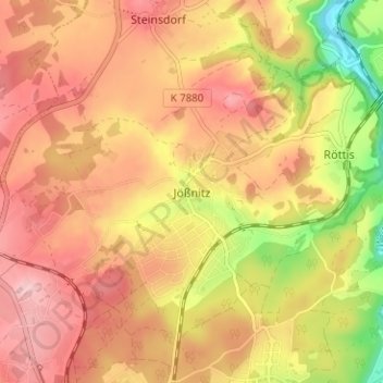
Name: Jößnitz topographic map, elevation, terrain.
Location: Jößnitz, Plauen, Vogtlandkreis, Sachsen, 08547, Deutschland (50.52354 12.11653 50.56354 12.15653)
Average elevation: 1,325 ft
Minimum elevation: 984 ft
Maximum elevation: 1,529 ft
Make a donation
Gear up for your next adventure:
As an Amazon Associate, this site earns from qualifying purchases at no extra cost to you.
Other topographic maps
Click on a map to view its topography, its elevation and its terrain.