
Make a donation
Gear up for your next adventure:
As an Amazon Associate, this site earns from qualifying purchases at no extra cost to you.
Bechtolsheim topographic map
Click on the map to display elevation.
Make a donation
Gear up for your next adventure:
As an Amazon Associate, this site earns from qualifying purchases at no extra cost to you.
Bechtolsheim
Zwischen dem 18. Jahrhundert bis Mitte der 1930er Jahre bestand eine kleine jüdische Gemeinde. Als Einrichtungen hatte die jüdische Gemeinde eine Synagoge, die vermutlich 1845 in einem bestehenden Gebäude eingerichtet wurde und bis 1900/1910 als religiöses Zentrum der jüdischen Gemeinde genutzt wurde. Auf Grund der stark zurückgegangenen Zahl der jüdischen Einwohner wurde die Synagoge geschlossen und das baufällige Gebäude 1925 abgerissen. Darüber hinaus gab es eine Religionsschule und ein rituelles Bad. Die Toten wurden auf dem jüdischen Friedhof auf Gau-Odernheimer Gemarkung an einer Anhöhe zum Petersberg beigesetzt.
Make a donation
Gear up for your next adventure:
As an Amazon Associate, this site earns from qualifying purchases at no extra cost to you.
About this map
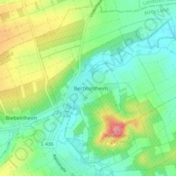
Name: Bechtolsheim topographic map, elevation, terrain.
Average elevation: 541 ft
Minimum elevation: 427 ft
Maximum elevation: 781 ft
Make a donation
Gear up for your next adventure:
As an Amazon Associate, this site earns from qualifying purchases at no extra cost to you.