
Kalimpong - II topographic map
Click on the map to display elevation.
About this map
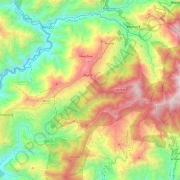
Name: Kalimpong - II topographic map, elevation, terrain.
Location: Kalimpong - II, Kalimpong district, West Bengal, India (27.00806 88.48041 27.19070 88.72026)
Average elevation: 3,740 ft
Minimum elevation: 745 ft
Maximum elevation: 8,071 ft
Other topographic maps
Click on a map to view its topography, its elevation and its terrain.
Lava
India > West Bengal > Kalimpong - II
Lava (also known as Lava Bazar) is a town in the Kalimpong II CD block in the Kalimpong subdivision of the Kalimpong district in the Indian state of West Bengal. As it lies in the high altitude, so it is also visible from high altitude towns and villages of East Sikkim, high areas of Bhutan and also from…
Average elevation: 6,335 ft
Rishyap
India > West Bengal > Kalimpong - II
Rishyap is located at 27.03N & 88.18E. It has an average elevation of 2591 meters (8500 feet).
Average elevation: 5,869 ft
Lava
India > West Bengal > Kalimpong - II
Lava (also known as Lava Bazar) is a town in the Kalimpong II CD block in the Kalimpong subdivision of the Kalimpong district in the Indian state of West Bengal. As it lies in the high altitude, so it is also visible from high altitude towns and villages of East Sikkim, high areas of Bhutan and also from…
Average elevation: 6,335 ft