
Make a donation
Gear up for your next adventure:
As an Amazon Associate, this site earns from qualifying purchases at no extra cost to you.
Pangkalpinang topographic map
Click on the map to display elevation.
Make a donation
Gear up for your next adventure:
As an Amazon Associate, this site earns from qualifying purchases at no extra cost to you.
Pangkalpinang
The city's topography is generally undulating and hilly, with an altitude of 20–50 metres (66–164 ft) above sea level. Hilly areas are primarily in the west and south, including Mount Girimaya (50 metres above sea level) and Tower Hill. A 290-hectare (720-acre) urban forest is in the Old Village area. An area of 1,562 hectares (3,860 acres) is under cultivation for food crops, fisheries and forestry. Fallow land is 1,163 hectares (2,870 acres), and 4,130 hectares (10,200 acres) are developed. The remaining 2,085 hectares (5,150 acres) are swamps and forest.
Make a donation
Gear up for your next adventure:
As an Amazon Associate, this site earns from qualifying purchases at no extra cost to you.
About this map
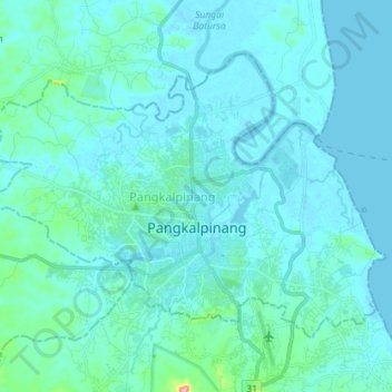
Name: Pangkalpinang topographic map, elevation, terrain.
Location: Pangkalpinang, Bangka-Belitung Islands, Sumatra, Indonesia (-2.16100 106.03944 -2.05750 106.18222)
Average elevation: 46 ft
Minimum elevation: -13 ft
Maximum elevation: 495 ft
Make a donation
Gear up for your next adventure:
As an Amazon Associate, this site earns from qualifying purchases at no extra cost to you.
Other topographic maps
Click on a map to view its topography, its elevation and its terrain.
Make a donation
Gear up for your next adventure:
As an Amazon Associate, this site earns from qualifying purchases at no extra cost to you.