Geolocate

Manuto topographic map

Click on the map to display elevation.

About this map

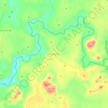
Name: Manuto topographic map, elevation, terrain.

Location: Manuto, Quezon, Bukidnon, Northern Mindanao, 8715, Philippines (7.67893 125.06934 7.71893 125.10934)

Average elevation: 892 ft

Minimum elevation: 659 ft

Maximum elevation: 1,204 ft

Other topographic maps

Click on a map to view its topography, its elevation and its terrain.

Manuto River

Philippines > Bukidnon > Quezon > Cawayan

Average elevation: 1,329 ft

Pulangi Lake

Philippines > Bukidnon > Quezon

Average elevation: 988 ft

Gear up for your next adventure:

🔊Portable Camp Speaker - Music and alerts at camp
🧣Hiking Neck Gaiter - Multi‑use neck protection for outdoor weather
📶Satellite Messenger - Communication device off‑grid
🧢Sun Protection Hats - Wide-brimmed and UPF-rated hats for high-altitude sun safety
🧭Pro Hiking Compasses - High-accuracy liquid-filled compasses for topographic orientation

As an Amazon Associate, this site earns from qualifying purchases at no extra cost to you.