Geolocate

Husi topographic map

Click on the map to display elevation.

About this map

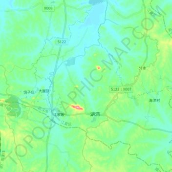
Name: Husi topographic map, elevation, terrain.

Location: Husi, Jiangxia District, Wuhan, Hubei, China (29.97196 114.40214 30.10876 114.53927)

Average elevation: 128 ft

Minimum elevation: 46 ft

Maximum elevation: 427 ft

Gear up for your next adventure:

🥤Water Filter Bottle - All‑in‑one filter bottle for safe hydration
🧷Carabiner Set - Durable clips for gear attachment
🔦Compact Flashlight - Reliable flashlight for emergencies
🧯Emergency Survival Kit - All‑in‑one survival essentials for the backcountry
🏕️Tent Footprint - Protect your tent base from wear

As an Amazon Associate, this site earns from qualifying purchases at no extra cost to you.