
Make a donation
Gear up for your next adventure:
As an Amazon Associate, this site earns from qualifying purchases at no extra cost to you.
Soria topographic map
Click on the map to display elevation.
Make a donation
Gear up for your next adventure:
As an Amazon Associate, this site earns from qualifying purchases at no extra cost to you.
Soria
Soria has an oceanic climate (Köppen: Cfb). Due to its altitude, winters in Soria are very cold by Spanish standards (3.2 °C (38 °F) in January) with almost 84 frost days per year. Summers are dry and warm (average 20.5 °C (69 °F) in July) with the daytime temperature usually around 29 °C (84 °F). Temperatures above 35 °C (95 °F) are not rare in summer, while lows can go under 10 °C (50 °F) at nights. It has scant rainfall (512 mm per year) and spring is the wettest season. The low rainfall is in spite of its high elevation as the maritime Atlantic low-pressure systems are often blocked by the mountains closer to the coast. It is the coldest Spanish provincial capital.
Make a donation
Gear up for your next adventure:
As an Amazon Associate, this site earns from qualifying purchases at no extra cost to you.
About this map
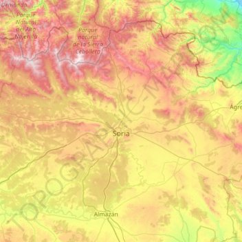
Name: Soria topographic map, elevation, terrain.
Location: Soria, Castile and León, Spain (41.67633 -3.01677 41.93285 -1.91334)
Average elevation: 3,661 ft
Minimum elevation: 1,355 ft
Maximum elevation: 7,182 ft
Make a donation
Gear up for your next adventure:
As an Amazon Associate, this site earns from qualifying purchases at no extra cost to you.
Other topographic maps
Click on a map to view its topography, its elevation and its terrain.
Santo Tomás de las Ollas
Spain > Castile and León > El Bierzo > Ponferrada
Average elevation: 1,909 ft