
Make a donation
Gear up for your next adventure:
As an Amazon Associate, this site earns from qualifying purchases at no extra cost to you.
Kelantan River topographic map
Click on the map to display elevation.
Make a donation
Gear up for your next adventure:
As an Amazon Associate, this site earns from qualifying purchases at no extra cost to you.
Kelantan River
The river's tributaries rise in the forested mountains in the Gua Musang region in southern Kelantan, where many Orang Asli tribes live. The area is known for its karst topography, dotted with mogotes with numerous caves beneath them. Some cave systems along the Nenggiri River, the river's left tributary, show evidence of habitation going back to 9000 years ago, such as Gua Cha near Kuala Betis.
Make a donation
Gear up for your next adventure:
As an Amazon Associate, this site earns from qualifying purchases at no extra cost to you.
About this map
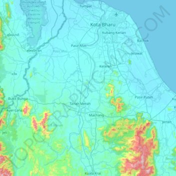
Name: Kelantan River topographic map, elevation, terrain.
Location: Kelantan River, Kampung Paloh, Tanah Merah, Kelantan, Malaysia (5.52095 102.10375 6.22347 102.25033)
Average elevation: 233 ft
Minimum elevation: -7 ft
Maximum elevation: 3,002 ft
Make a donation
Gear up for your next adventure:
As an Amazon Associate, this site earns from qualifying purchases at no extra cost to you.