
Make a donation
Gear up for your next adventure:
As an Amazon Associate, this site earns from qualifying purchases at no extra cost to you.
Évora topographic map
Click on the map to display elevation.
Make a donation
Gear up for your next adventure:
As an Amazon Associate, this site earns from qualifying purchases at no extra cost to you.
Évora
Évora (altitude 300m) is situated in Alentejo, a large region of wide plains in the south of Portugal, bordered to the North by the Tagus River and to the South by the region of Algarve. The city is 140 km (87 mi) from the capital city Lisbon, and 80 km (50 mi) from Badajoz at the Spanish border. It is the chief city of the region.
Make a donation
Gear up for your next adventure:
As an Amazon Associate, this site earns from qualifying purchases at no extra cost to you.
About this map
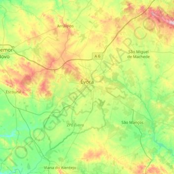
Name: Évora topographic map, elevation, terrain.
Location: Évora, Portugal (38.34068 -8.16570 38.76820 -7.55494)
Average elevation: 810 ft
Minimum elevation: 367 ft
Maximum elevation: 1,804 ft
Make a donation
Gear up for your next adventure:
As an Amazon Associate, this site earns from qualifying purchases at no extra cost to you.