
Make a donation
Gear up for your next adventure:
As an Amazon Associate, this site earns from qualifying purchases at no extra cost to you.
Bernkastel-Kues topographic map
Click on the map to display elevation.
Make a donation
Gear up for your next adventure:
As an Amazon Associate, this site earns from qualifying purchases at no extra cost to you.
Bernkastel-Kues
Bernkastel-Kues lies in the Mosel valley, roughly 50 km (31 mi) from Trier. The greatest elevation is the Olymp (415 m above sea level), and the lowest point (107 m above sea level) lies on the Mosel's banks. The municipal area totals 23 657 101 m2, of which 7 815 899 m2 is used for agriculture, thereby making Bernkastel-Kues one of the Middle Moselle's biggest towns by land area.
Make a donation
Gear up for your next adventure:
As an Amazon Associate, this site earns from qualifying purchases at no extra cost to you.
About this map
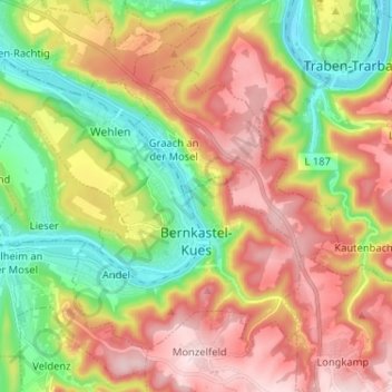
Name: Bernkastel-Kues topographic map, elevation, terrain.
Average elevation: 883 ft
Minimum elevation: 318 ft
Maximum elevation: 1,503 ft
Make a donation
Gear up for your next adventure:
As an Amazon Associate, this site earns from qualifying purchases at no extra cost to you.