
Las Lomas topographic map
Click on the map to display elevation.
Las Lomas
Las Lomas (Spanish for "The Hills") is an unincorporated community and census-designated place (CDP) in Monterey County, California, United States. Las Lomas is located 7 miles (11 km) north-northwest of Prunedale. The elevation is 43 feet (13 m). The population was 3,046 at the 2020 census.
About this map
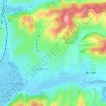
Name: Las Lomas topographic map, elevation, terrain.
Location: Las Lomas, Monterey County, California, United States (36.85897 -121.74033 36.87930 -121.72233)
Average elevation: 115 ft
Minimum elevation: -20 ft
Maximum elevation: 387 ft
Monterey County trails, hiking, mountain biking, running and outdoor activities
Other topographic maps
Click on a map to view its topography, its elevation and its terrain.
Pfeiffer Big Sur State Park
United States > California > Monterey County > Big Sur Village
Average elevation: 991 ft
Prunedale
United States > California > Monterey County > Prunedale
Prunedale is a census-designated place in Monterey County, California. Prunedale is located 8 miles (13 km) north of Salinas, at an elevation of 92 feet (28 m). The population was 17,560 residents at the time of the 2010 census, up from 16,432 at the 2000 census. Plum trees were grown in Prunedale in the early…
Average elevation: 226 ft
Prunedale
United States > California > Monterey County
Prunedale is a unincorporated community in Monterey County, California, United States. It is located 8 miles (13 km) north of Salinas at an elevation of 92 feet (28 m). The population was 18,885 as of the 2020 census, up from 17,560 in 2010. For statistical purposes, the United States Census Bureau has defined…
Average elevation: 341 ft
Sand City
United States > California > Monterey County
Sand City is a city in Monterey County, California, United States, located on the shores of Monterey Bay, and surrounded on most sides by the larger city of Seaside. Sand City is located 2 miles (3 km) northeast of Monterey, at an elevation of 72 feet (22 m). The population was 325 at the 2020 census. The city…
Average elevation: 36 ft
Greenfield
United States > California > Monterey County
Greenfield is a city in Monterey County, California, United States. Formerly Clarke Colony, it lies in the Salinas Valley, 33 miles (53 km) southeast of Salinas, at an elevation of 289 feet (88 m). As of the 2020 census, the population was 18,937, up from 16,330 in the 2010 census. Its most well-known public…
Average elevation: 282 ft