
Make a donation
Gear up for your next adventure:
As an Amazon Associate, this site earns from qualifying purchases at no extra cost to you.
Hochheim am Main topographic map
Click on the map to display elevation.
Make a donation
Gear up for your next adventure:
As an Amazon Associate, this site earns from qualifying purchases at no extra cost to you.
Hochheim am Main
Die Stadt Hochheim liegt etwa 35 Meter über der Untermainebene auf einer Geländestufe am Südrand des Main-Taunus-Vorlandes. Der Südhang dieser sich auf etwa fünf Kilometer Länge erstreckenden Geländestufe besteht, teilweise bis dicht ans Mainufer, aus Weinbergen. Von den Weinbergen und vom südlichen Stadtrand gibt es eine Fernsicht bis Darmstadt, zur Neunkircher Höhe im Odenwald, zu der markanten Spitze des Melibokus an der Bergstraße in 38 Kilometern Entfernung und schließlich bis Oppenheim in Rheinhessen. Die Stadtsilhouette ist aus südlicher Richtung weit sichtbar.
Make a donation
Gear up for your next adventure:
As an Amazon Associate, this site earns from qualifying purchases at no extra cost to you.
About this map
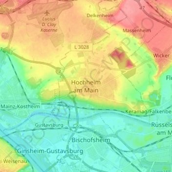
Name: Hochheim am Main topographic map, elevation, terrain.
Average elevation: 367 ft
Minimum elevation: 266 ft
Maximum elevation: 525 ft
Make a donation
Gear up for your next adventure:
As an Amazon Associate, this site earns from qualifying purchases at no extra cost to you.