Geolocate

Aylsham topographic map

Click on the map to display elevation.

About this map

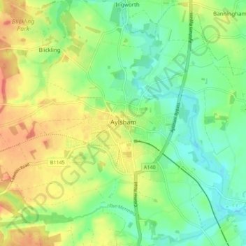
Name: Aylsham topographic map, elevation, terrain.

Location: Aylsham, Broadland, Norfolk, England, United Kingdom (52.77020 1.20589 52.81929 1.28997)

Average elevation: 82 ft

Minimum elevation: 16 ft

Maximum elevation: 167 ft

Other topographic maps

Click on a map to view its topography, its elevation and its terrain.

Thorpe End

United Kingdom > England > Norfolk > Broadland

Average elevation: 102 ft

Strumpshaw Hill

United Kingdom > England > Norfolk > Broadland

Average elevation: 62 ft

New Rackheath

United Kingdom > England > Norfolk > Broadland

Average elevation: 92 ft

Gear up for your next adventure:

📚Navigation Handbooks - Master the art of reading topographic maps and using a compass
🪵Folding Camp Saw - Compact saw for wood and campsite work
🔭Telescopic Hiking Pole - Adjustable pole for hiking stability
🏔️Mountain Trail Maps - High‑detail maps for popular peaks
🎒Hydration Pack - Hands‑free water reservoir for long hikes

As an Amazon Associate, this site earns from qualifying purchases at no extra cost to you.