Geolocate

Barbil topographic map

Click on the map to display elevation.

Barbil

Barbil is located at 22°07′N 85°24′E / 22.12°N 85.40°E / 22.12; 85.40. It has an average elevation of 477 m (1,565 ft). Barbil is fully surrounded by hills.

Wikipedia (CC-BY-SA 3.0)

About this map

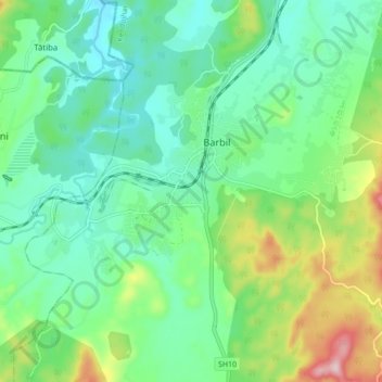
Name: Barbil topographic map, elevation, terrain.

Location: Barbil, Kendujhar, Odisha, 758035, India (22.07189 85.34685 22.15189 85.42685)

Average elevation: 1,588 ft

Minimum elevation: 1,358 ft

Maximum elevation: 2,844 ft

Gear up for your next adventure:

☀️Outdoor Sunscreen - High protection sunscreen for outdoor activities
🪑Portable Camp Table - Compact table for campsite meals
🪶Fire Starter Kit - Reliable fire starter for survival and camping
🚪Portable Camp Chair - Foldable chair for comfort at camp
🧣Hiking Neck Gaiter - Multi‑use neck protection for outdoor weather

As an Amazon Associate, this site earns from qualifying purchases at no extra cost to you.