Geolocate

Manzanillo topographic map

Click on the map to display elevation.

About this map

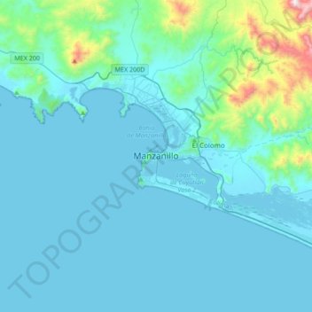
Name: Manzanillo topographic map, elevation, terrain.

Location: Manzanillo, Colima, 28200, Mexico (18.89063 -104.47600 19.21063 -104.15600)

Average elevation: 374 ft

Minimum elevation: -7 ft

Maximum elevation: 3,891 ft

Gear up for your next adventure:

🦟Ultrasonic Repellers - Create a bug-free zone at your camp or rest stop
💧Water Purification System - Clean water on the trail with reliable purifiers
🥩Freeze-Dried Meals - Nutritious and lightweight food for remote expeditions
🛠️Backpacking Tool Kit - Essential toolkit for outdoor repairs
🔦LED Headlamp - Bright and durable LED headlamp for night navigation

As an Amazon Associate, this site earns from qualifying purchases at no extra cost to you.