
Make a donation
Gear up for your next adventure:
As an Amazon Associate, this site earns from qualifying purchases at no extra cost to you.
Waterbury topographic map
Click on the map to display elevation.
Make a donation
Gear up for your next adventure:
As an Amazon Associate, this site earns from qualifying purchases at no extra cost to you.
About this map
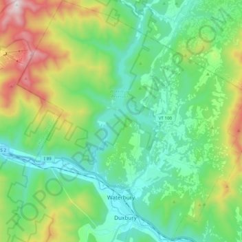
Name: Waterbury topographic map, elevation, terrain.
Location: Waterbury, Washington County, Vermont, United States (44.31293 -72.83983 44.45152 -72.65434)
Average elevation: 1,253 ft
Minimum elevation: 328 ft
Maximum elevation: 3,684 ft
Washington County trails, hiking, mountain biking, running and outdoor activities
Make a donation
Gear up for your next adventure:
As an Amazon Associate, this site earns from qualifying purchases at no extra cost to you.
Other topographic maps
Click on a map to view its topography, its elevation and its terrain.
Northfield Center
United States > Vermont > Washington County > Northfield
Average elevation: 1,119 ft
Make a donation
Gear up for your next adventure:
As an Amazon Associate, this site earns from qualifying purchases at no extra cost to you.
Northfield Center
United States > Vermont > Washington County > Northfield
Average elevation: 1,119 ft
South Cabot
United States > Vermont > Washington County > Cabot > South Cabot
Average elevation: 1,575 ft
Make a donation
Gear up for your next adventure:
As an Amazon Associate, this site earns from qualifying purchases at no extra cost to you.