
Make a donation
Gear up for your next adventure:
As an Amazon Associate, this site earns from qualifying purchases at no extra cost to you.
Wald-Erlenbach topographic map
Click on the map to display elevation.
Make a donation
Gear up for your next adventure:
As an Amazon Associate, this site earns from qualifying purchases at no extra cost to you.
Wald-Erlenbach
Die Historisch-topographisch-statistische Beschreibung des Fürstenthums Lorsch, oder Kirchengeschichte des Oberrheingaues von 1812 berichtet unter dem Abschnitt. Heppenheimer Dörfer.
Make a donation
Gear up for your next adventure:
As an Amazon Associate, this site earns from qualifying purchases at no extra cost to you.
About this map
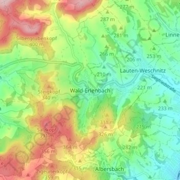
Name: Wald-Erlenbach topographic map, elevation, terrain.
Average elevation: 886 ft
Minimum elevation: 581 ft
Maximum elevation: 1,365 ft
Make a donation
Gear up for your next adventure:
As an Amazon Associate, this site earns from qualifying purchases at no extra cost to you.
Other topographic maps
Click on a map to view its topography, its elevation and its terrain.