Geolocate

Carthage topographic map

Click on the map to display elevation.

About this map

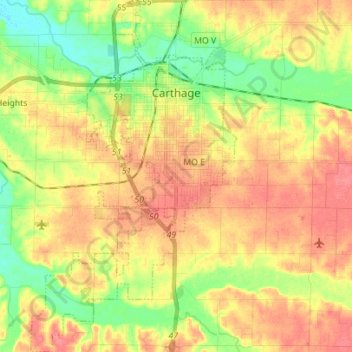
Name: Carthage topographic map, elevation, terrain.

Location: Carthage, Jasper County, Missouri, 64836, United States (37.09465 -94.36789 37.20564 -94.28587)

Average elevation: 1,014 ft

Minimum elevation: 909 ft

Maximum elevation: 1,102 ft

Jasper County trails, hiking, mountain biking, running and outdoor activities

Other topographic maps

Click on a map to view its topography, its elevation and its terrain.

West Joplin

United States > Missouri > Jasper County > Joplin

Average elevation: 1,017 ft

Pleasant Valley

United States > Missouri > Jasper County

Average elevation: 1,030 ft

Gear up for your next adventure:

🗺️NatGeo Topo Maps - High-quality waterproof printed topographic maps of US Parks
🧭Pro Hiking Compasses - High-accuracy liquid-filled compasses for topographic orientation
🪶Trail Camera - Capture wildlife on your hikes
❄️Traction Cleats - Prevent slips on icy trails during winter hikes
🪑Portable Camp Table - Compact table for campsite meals

As an Amazon Associate, this site earns from qualifying purchases at no extra cost to you.