Geolocate

Osceola topographic map

Click on the map to display elevation.

About this map

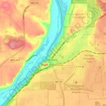
Name: Osceola topographic map, elevation, terrain.

Location: Osceola, Polk County, Wisconsin, United States (45.29998 -92.73259 45.34831 -92.66644)

Average elevation: 856 ft

Minimum elevation: 673 ft

Maximum elevation: 991 ft

Polk County trails, hiking, mountain biking, running and outdoor activities

Other topographic maps

Click on a map to view its topography, its elevation and its terrain.

Tula Lake

United States > Wisconsin > Polk County

Average elevation: 1,158 ft

Mackie Lake

United States > Wisconsin > Polk County > Town of McKinley

Average elevation: 1,191 ft

Gear up for your next adventure:

🧴Hand Sanitizer - Keep hands clean while hiking
🦺Reflective Outdoor Gear - Safety gear for low‑light conditions
🗻Climbing Gear Basics - Essential gear for beginner climbers
🚑Emergency Bivvies - Heat-reflective sleeping bags for survival situations
🧥Waterproof Jacket for Hiking - Breathable and rugged rain jacket for outdoor excursions

As an Amazon Associate, this site earns from qualifying purchases at no extra cost to you.