
Saint Paul topographic map
Interactive map
Click on the map to display elevation.
About this map
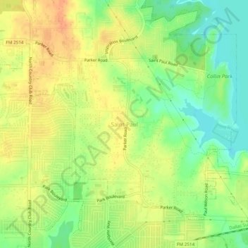
Name: Saint Paul topographic map, elevation, terrain.
Location: Saint Paul, Collin County, Texas, 75098, United States (33.02115 -96.57045 33.06115 -96.53045)
Average elevation: 541 ft
Minimum elevation: 476 ft
Maximum elevation: 594 ft
Collin County trails, hiking, mountain biking, running and outdoor activities
Other topographic maps
Click on a map to view its topography, its elevation and its terrain.
Dr. Charels B. McKissick Park
United States > Texas > Collin County > McKinney
Average elevation: 673 ft